Breiðamerkurjökull – The Glacier of the Crystal Blue Ice Caves

Troll team
Planning a trip on the South Coast and not sure of what should be on your unmissable list? Many people have heard of Jökulsárlón, “The Glacier Lagoon”, but few know the name or the history of the glacier that created Jökulsárlón and the crystal blue ice caves: Breiðamerkurjökull. Approximately a 5.5-hour drive from Reykjavik in the winter time, the lagoon is the jewel of Iceland and is not to be missed even if you’re on a short two-day stopover – it is one of Vatnajökull’s most famous outlet glacier for a reason!
About Breiðamerkurjökull
Breiðamerkurjökull (“Breidamerkurjökull”) or “Breidó” to the locals, is a glacial tongue that flows down the mountains from Vatnajökull. It is responsible for the famous Jökulsárlón glacier lagoon, Diamond Beach, and the crystal ice caves that qualified guides take tours to every winter.
Breidamerkurjökull is the largest of 35 glacial tongues that come of the ice cap Vatnajökull. If you think of an ice cap like the palm of your hand, the glacial tongues that come down the mountains are the “fingers”. Vatnajökull is the largest ice cap in Europe and is roughly 8.000m squared, and takes up almost the entire south-east corner of Iceland.
A glacier is more than just ice on a mountain. The glaciers are formed on the ice cap year-round, with the snow taking decades to squash down into the compact glacier ice that will continue its slow, grinding journey down the mountains. The new glacier ice pushes the older glacier ice over the edge of the mountain and down into the valleys along the glacier tongues
What does Breidamerkurjökull mean?
Braided-murky-wha? What does it mean? Breidamerkurjökull means “wide, woodland glacier” in Icelandic. Jökulsárlón also translates to “glacier river lagoon”, so when you break down Icelandic words you can begin to see patterns emerging. We use the word “jökull” for all of our glaciers and some of the volcanoes underneath them.
When Icelanders first settled the south-east of Iceland they called it “Little Shire” or Litlahérað because the climate between 874 and 1300 AD was warmer than it is today. There were lots of trees, swamps and valleys good for farming. At the time, the area was not considered remote because the harbour of Höfn and the original settlement of Svínafell and Ingólfshöfði were quite close. Recently guides have found evidence of the forests as the glaciers have receded, and have dated some of the wood found to 3.000 years ago.
In 1362 Öræfajökull erupted and flooded the area with poisonous gases and a deadly spray of rock and glacial floods. The area was uninhabitable for around 40 years afterwards, and when people came to live here again in 1400 it became known as Öræfi or “The Wasteland”. The ash and gas had affected the atmosphere above Iceland and had plunged it into darkness and lower temperatures, decreasing livestock, farms, trees and the quality of life for people in the region.
How were the Glacier Lagoon and the Diamond Beach formed?
Jökulsárlón started forming in the 1940s-1950s, and so is only about 70 years old. The lagoon is about 250m deep below sea level, and is the deepest part of Iceland. When the glacier advanced swiftly down the valley during 1700 – 1890 during the “mini ice ages”, it scraped away the ground and pushed it up into the moraine hills around the lagoon. The moraine hills next to you as you drive to the pull off road are from 1890’s, when the glacier stopped advancing and began to slowly recede back to where the edge is today.
All of the meltwater from the glacier filled up the scraped-out depression left by the glacier and connected the edge of the glacier to the ocean. With the tide now able to come in and reach the edge of the glacier, huge blocks of ice became unstable and began to calve off into the lagoon to form icebergs. So, to go back to our hand metaphor, an iceberg is just a fingernail clipping coming off the finger of the hand, or ice cap!
Some of the icebergs in the lagoon have been there for over three years. Because we only see about 10% of the massive block of ice, everytime the iceberg breaks a little and rolls, it’s like a brand new art sculpture. The sea tide comes in and collects all the ice fragments that break off the larger icebergs. In the afternoon, when the tide goes out, the baby icebergs are carried out to sea and back around into the shore where they wash up, polished by the ocean.
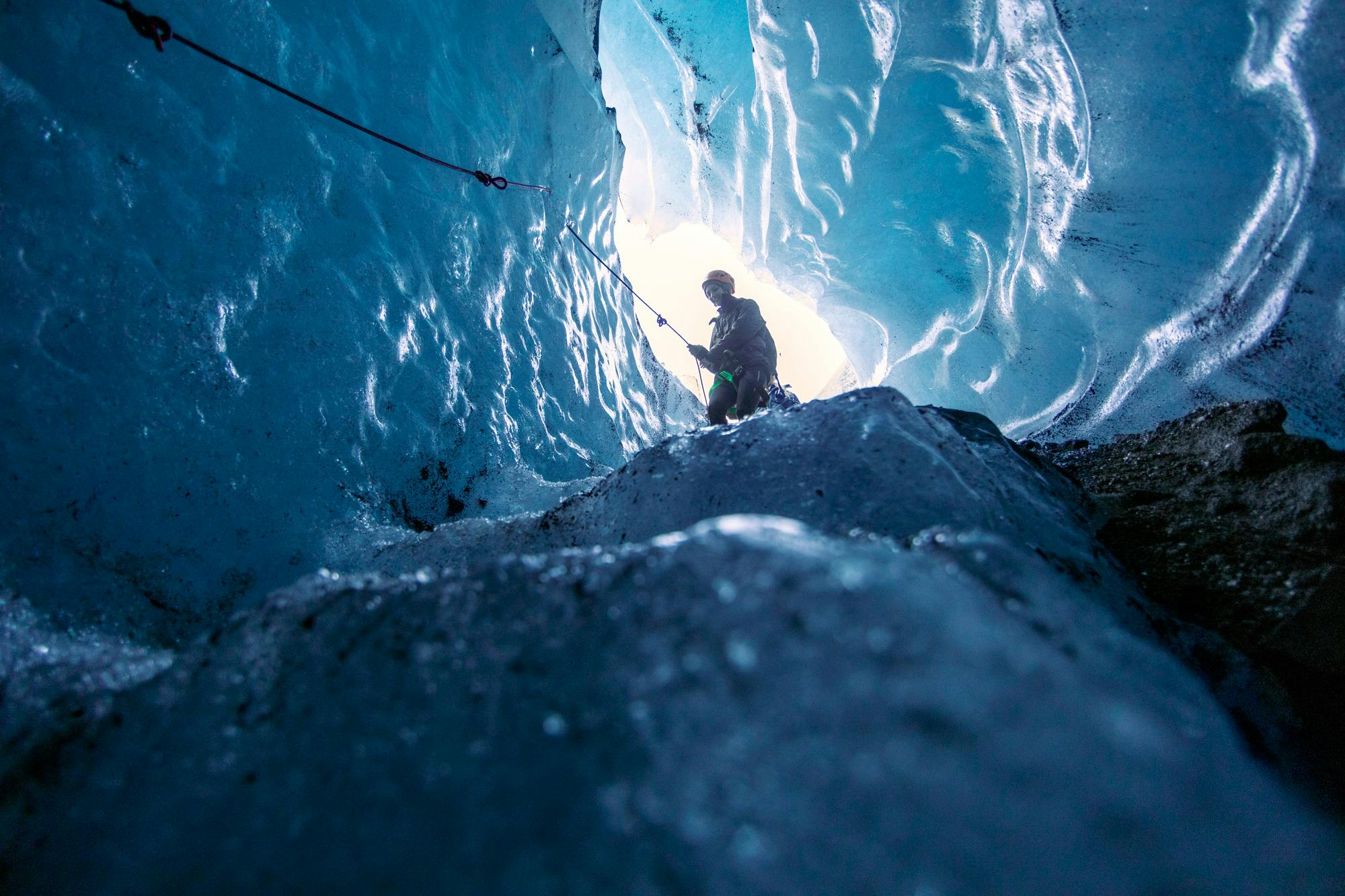
Crystal Ice Caves on Breidamerkurjökull
So, how are the gorgeous ice caves formed? Normally, an ice cave is created by the flow of water from the surface of the glacier to the bottom and out into a lagoon or stream. The water makes pipes or a plumbing system through the glacier. If you slice a glacier sideways it will look like a piece of swiss cheese with tunnels going vertically and horizontally through the ice.
There is quite a tradition of naming ice caves in the south, and so you may see lots of different names: Crystal Ice Cave, Anaconda, Blue Heaven, Treasure Island… Our guides are inspired by the new shapes and colours they see and love to give them evocative names. You can try our Crystal Ice Cave tour that departs on a SuperJeep from Jokulsárlón to experience it yourself.
Beautiful blue colour happens in the process of compressing snow into ice. A lot of the oxygen is removed and the ice becomes four times as hard as regular frozen water. Ice and water are natural filters for light, so when red, blue, and yellow light waves that make up white light enter the ice, only the blue light is strong enough to be seen on the other side. Sometimes if the sun is strong enough and very yellow in winter, the ice will look green and aqua. If the ice is too thick and the light cannot shine through, or there’s lots of volcanic ash inside, the blue will be more subtle.
The reason the ice caves in Breidamerkurjökull have such clear ice is because the glacier is so old and has spent more time squeezing the air out of the ice. The ice at the terminus is around 1200 years old. The Breidamerkurjökull valley is very wide and flat and so there isn’t a lot of natural topography assisting in the ice moving down the hill, only the production of new ice at the top.
We don’t normally take clients into ice caves in the summer because it can be very risky. The amount of water, the heat and the constant movement of the glacier makes caves unstable and more likely to collapse. In winter time normally the water level decreases, the ice stops melting, and the glacier slows down. Ice caves like the Katla Ice Cave are safe to go in in the summertime because it is structurally different to the bright blue ice caves in winter.
Breidamerkurjökull as a filming location
Lots of people ask if Game of Thrones was filmed at the glacier lagoon. It was filmed about an hour east on Svínafellsjökull near Skaftafell, but you can no longer drive to the glacier or take a tour because there is a serious warning about a landslide. You can see the beautiful glacier from the road, but we advise against going any closer. I’m sure you won’t have a hard time imagining life in Winterfell or north of the wall once you get to the glacier lagoon though, it’s like being transported to another place…
Fear not, the trolls also have tours available in Skaftafell area. If you are hunting for ice caves, you can go on a glacier hiking tour that visits a blue ice cave, check Skaftafell Blue Ice Cave Adventure and Glacier Hike. In case you are looking for ice caves closer to Reykjavík, we have a tour that visits a stunning area in the countryside near Vík only 2,5 hours drive from Reykjavík, check our Ice Cave by Katla Volcano, it includes pickup from a Vík on a SuperJeeo and involves very little hiking and is the perfect tour for families traveling with kids.
James Bond A View to Kill was filmed on the lagoon in 1984. In order to freeze the lagoon for Die Another Day in 2002, they had to stop the salt water from entering in so that the freshwater could freeze. Lara Croft Tomb Raider was filmed here in 2000. They used the Jökulsárlón duckies to go across the lagoon and onto the icecap in “Siberia”.
Justin Bieber’s I’ll Show You music video was also filmed in part at Jökulsárlón and Diamond Beach, but we don’t recommend getting down to your tighty-whities and taking a dip like he did. The water, especially in winter, is extremely cold and can very quickly cause life-threatening hypothermia. Be an excellent and respectful tourist and don’t give the national park rangers a heart attack out of concern for you!
Join an unforgettable adventure on Vatnajökull, Europe’s largest glacier, located in the beautiful Skaftafell area. The highlight of this tour is the chance to step inside a naturally formed blue ice cave, an experience very few people ever get to have.


 Skaftafell
 Meet on location
 Medium
 4 Hours
Are you ready to turn into an adventurous "Ice-cave Explorer Troll" 🧌 ? Come join our Tröll Expeditions team on an extraordinary journey to the majestic Katla Ice Cave. This unique experience is perfect for those who are seeking an off-the-beaten-path adventure away from the crowds and looking forward to being lost in the wild, breathtaking landscapes of Icelandic nature. Our experienced glacier guides will lead you through the mysterious wilderness in a Super-jeep from Vik, sharing fascinating tales about the area, interesting facts related to the Katla volcano, and geological insights along the way. Safety is always our priority: our guides will provide you with helmets, headlamps, and crampons to ensure a smooth journey. Witness the awe-inspiring combination of fire and ice as you explore the volcanic glacier outlets of Mýrdalsjökull glacier, a remote location inaccessible to most. With panoramic views, stunning ice formations and tunnels, and the chance to see real Game of Thrones Dragon-Glass, this tour is one of Iceland's best-kept secrets.
Vik 3 Hours Easy All Year
Fire and Ice
Volcanoes under Breidamerkurjökull
All the ash you see on the surface of the glacier is from the 2011 Grímsvötn “Grím’s Lake” and 2014 Bárðarbunga “Bárðar’s Bulging Belly” eruptions The ash spread from east to west, all over the ice cap, and the glaciers are still going through the process of cleaning off and absorbing all the ash. Locals say because of the thin layer of ash on the surface attracting heat to the ice, Breidamerkurjökull has been melting faster than some of the other glacial tongues in the same area.
There has been a lot of discussion over the last year about a very active volcano called Öræfijökull, situated above Skaftafell and Svínafell further to the west. Have no fear, however, Breidamerkurjökull is out of reach of the glacial floods, and all of the guides in the area are trained in what to do should there be an eruption!